Slope Distance to Horizontal Calculator
Convert measured slope distance into horizontal map run, vertical change, percent grade, angle, and corrected route distance for trails, driveways, ramps, surveys, and campsite approaches.
🗺Real Slope Presets
⚙Slope Measurement Inputs
📊Horizontal Distance Spec Grid
Horizontal distance is the plan-view run. It is shorter than slope distance whenever the line has meaningful rise or fall.
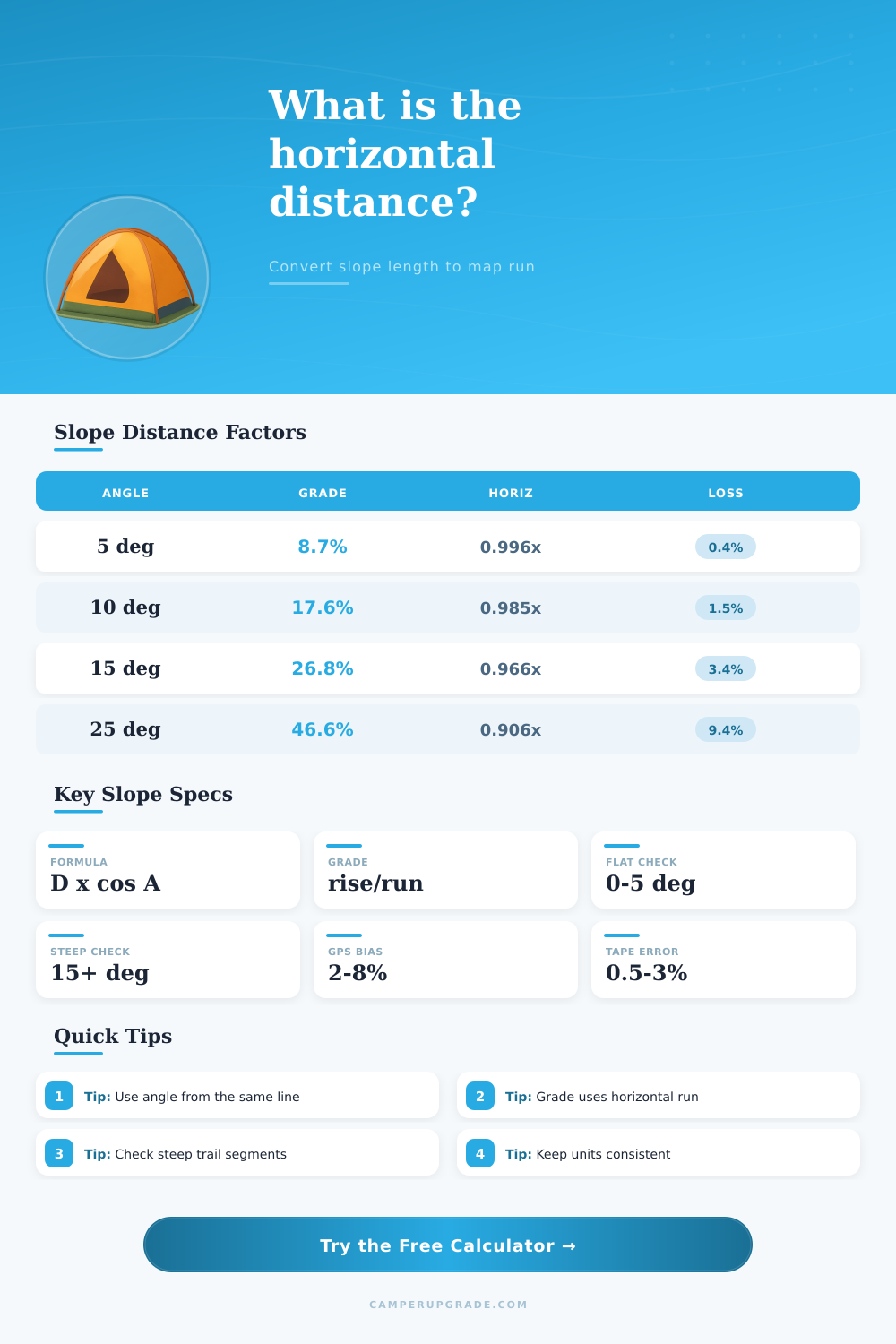
📐Angle, Grade, and Horizontal Factor Table
| Slope angle | Percent grade | Horizontal factor | Horizontal from 1000 ft slope | Correction note |
|---|---|---|---|---|
| 2° | 3.5% | 0.999x | 999 ft | Almost no visible map correction. |
| 5° | 8.7% | 0.996x | 996 ft | Small correction, but grade is already noticeable. |
| 10° | 17.6% | 0.985x | 985 ft | Useful correction for steep trails and driveways. |
| 15° | 26.8% | 0.966x | 966 ft | Slope length overstates map run by about 3.4%. |
| 20° | 36.4% | 0.940x | 940 ft | Steep enough that map and measured length diverge clearly. |
| 25° | 46.6% | 0.906x | 906 ft | Nearly a tenth of the slope length is vertical effect. |
| 30° | 57.7% | 0.866x | 866 ft | Very steep for most trail, ramp, or access road work. |
⚖Measurement Mode Table
| Mode | Best field measurement | Main formula | When to use it |
|---|---|---|---|
| Slope distance plus angle | Laser, tape, or wheel and inclinometer. | horizontal = distance x cos(angle) | Best when a clinometer shot matches the measured line. |
| Slope distance plus grade | Slope distance and known percent grade. | horizontal = distance / sqrt(1 + grade ratio squared) | Good when grade comes from a road profile or map app. |
| Slope distance plus vertical change | Tape distance and elevation change. | horizontal = sqrt(distance squared - rise squared) | Good for stairs, bridge lines, drainage falls, and short ramps. |
| Angle plus vertical change | Clinometer angle and elevation difference. | horizontal = rise / tan(angle) | Useful when slope length was not measured directly. |
| Grade plus vertical change | Known grade and rise or drop. | horizontal = rise / grade ratio | Useful for driveway layout, ramp planning, and site sketches. |
| Weighted cross-check | Several imperfect measurements. | Blends valid geometry solutions. | Use when GPS, tape, and clinometer readings disagree slightly. |
🛤Use Case Interpretation Table
| Purpose | Horizontal result matters for | Grade result matters for | Planning watch point |
|---|---|---|---|
| Trail map correction | Plan-view route distance, map scale, and segment comparison. | Effort, erosion potential, and descent feel. | Break long routes into slope segments instead of averaging the whole day. |
| Driveway or access road | Layout length across the site and clearing footprint. | Traction, clearance, drainage, and local maximum grade checks. | Short steep entries can be harder than the average driveway grade. |
| Ramp, bridge, or boardwalk | Horizontal span between endpoints. | Slope comfort and compliance checks. | Use the actual rules for accessibility or local building work. |
| Survey or site layout | Horizontal stationing and plan distance. | Profile notes and elevation change auditing. | For legal survey work, use calibrated instruments and professional methods. |
| Snow route or off-trail line | Map run and route spacing. | Travel effort and steep-terrain screening. | Snow stability and terrain traps are not solved by distance conversion alone. |
📝Preset Comparison Table
| Preset | Measurement style | Typical slope | What the calculator reveals |
|---|---|---|---|
| Trail traverse | GPS or wheel distance with grade check. | Moderate hillside trail. | Map run is slightly shorter than the recorded trail segment. |
| Summit pitch | Slope distance and clinometer angle. | Steep sustained climb. | Horizontal correction becomes large enough to affect segment planning. |
| Gravel driveway | Tape distance and rise. | Access grade. | Run, grade, and driveway warning band can be checked together. |
| RV leveling ramp | Short slope and vertical lift. | Small but precise ramp geometry. | Small vertical errors can matter more than map distance. |
| Clinometer shot | Angle and slope distance. | Site layout line. | Horizontal distance is calculated from the same sight line. |
💡Measurement Tips
The angle, grade, rise, and slope distance should describe the same segment. If the clinometer shot follows a direct fall line but the trail switchbacks, calculate those as separate lines.
Horizontal distance is the map run between endpoints. Walking or driving distance may be longer after bends, switchbacks, turns, or alignment changes.
This calculator is for planning and geometry checks. It does not replace local code requirements, accessibility standards, engineering design, snow safety evaluation, or professional survey methods.
When measuring distance with a tape measure or GPS device, the distance recorded will often be longer then the distance that is shown on the map. This difference between the two distances are due to the fact that the tape measure and GPS device measure the distance along the sloped ground between two points. The map display the flat distance between those two points.
The difference between the slope distance and the flat distance is referred to as a horizontal distance between the two points, and this tool will help to calculate that distance. The horizontal distance between two points are an important measurement to obtain, as the difference between the slope and horizontal distance can be significantly differently between two points on a slope. For instance, on a slope that measures 10 degree, the distance that is represented on the map is approximately one and a half percent of the slope distance shorter than the slope distance.
Find the flat distance between two points on a slope
On the other hand, a slope that measures 25 degrees will have a distance on the map that is approximately nine percent of the slope distance shorter than the actual slope distance between the two points. This horizontal distance is necessary to read maps correctly, to understand how property line relate to maps, and to understand how far an individual actualy travel. The calculator tool allow an individual to enter different measurements of a slope, and to provide the result of the calculation according to the provided measurements.
For instance, an individual can measure the slope distance between two points with a tape measure, the vertical change between those two points can be measured with a topographical map, the angle between two points can be measured with a clinometer or an phone application that measures angle, the grade of a slope can be represented as a percentage of the rise of the slope compared to the horizontal run of the slope. The distance between these two points does not need to be provided at the same time, as the calculator will determine which two distances are the most reliable and calculate the horizontal distance between the two provided point. In addition to the measurements of the slope, the calculator also include two different settings for the calculation of the horizontal distance.
One setting relate to the type of surface to be measured; different surfaces will provide different readings to an individual measuring slope distance. For instance, a trail that is pack will produce different results from a trail that is made of rock or snow. The other setting is for the inclusion of an uncertainty band around the calculated measurement; adding an uncertainty band will prevent the individual from providing false assurance about the accuracy of that calculated value.
Additionally, a route length factor can be included in the calculation of the horizontal distance; the route length factor can account for the additional distance that may be introduced into the calculation due to switchback or other bends within the route to be measured. As a result of these features, many individuals will find that the horizontal distance between two points on a slope is a necessary measurement for a variety of task. For instance, if an individual is required to obtain a permit for a driveway, the permit may specify that the maximum grade for that driveway is a certain percentage.
In this case, the horizontal distance would be used to determine if that driveway would meet the requirement of that permit. Similarly, if an individual is creating a trail map, the distance between each map point will need to be accurate in order to correctly calculate the mileage for that trail. Finally, if an individual is creating a ramp, it will need to meet certain accessibility standard; those standards refer to the plan-view distance of the ramp, or the horizontal distance of the ramp.
Thus, while it is easy to measure the slope distance between two points, the horizontal distance is the measurement that will be used for other decisions. Beyond the ability of the distance between the slope and the horizontal distance to be applied to map readings, effort estimation, and layout plan for areas to be treated or constructed, the use of the distance between slope and horizontal distance can be used in a variety of other way. For instance, one can use the horizontal distance between two points to determine the length of a ski track; while the ski track may be moderate on the map, it may have a long required climb to reach the top of the ski track.
Similarly, the straight line distance between two points on a map for constructing a bridge may be short, but the horizontal distance between those two points is the distance that the bridge will span over the creek. In each of these case, it is important that the measurements are obtained early in the planning process for these project. If the horizontal distance is not determined before beginning a project, the individual may experience surprise when purchasing the necessary material for that project.
Another reason to calculate the horizontal distance between two points is to ensure that the slope distance and the angle or grade entered into the calculator represent the same segment of the ground. For instance, if an individual use a clinometer to measure the angle of a slope, but the path to travel along the slope includes switchbacks, the two measurements are not describing the same segment of the ground. In this instance, if the individual attempted to use the calculator to determine the distance between these two points, the horizontal distance will be incorrect.
Thus, any calculation performed by the calculator is only helpful if the individual ensure that both the slope distance and grade entered into the calculator represent the same segment of the ground. In addition to determining the horizontal distance between two points, the calculator also display the grade and the angle between the two points. The horizontal distance between the two points can be used for map work, effort estimations for completing task on the slope, and for determining any layout plans for the area to be treated.
These use of the distance between the two points should not use the original distance that was used to calculate the horizontal distance; the slope distance between the two points is often longer than the distance that is measured between the two points on a map or that is used to make any layout plan. Thus, even if the difference between the two distances is small when the slope is relatively flat, using the horizontal distance for any of these task is necessary. Youll find that the accuracy of your measurements depends on the slope distance.
It’s better to use the horizontal distance for any of these task is necessary.