Radio Line of Sight Range Calculator
Estimate VHF, UHF, GMRS, marine, and camp radio horizon from antenna height, terrain clutter, effective earth factor, and Fresnel clearance.
Calculation breakdown
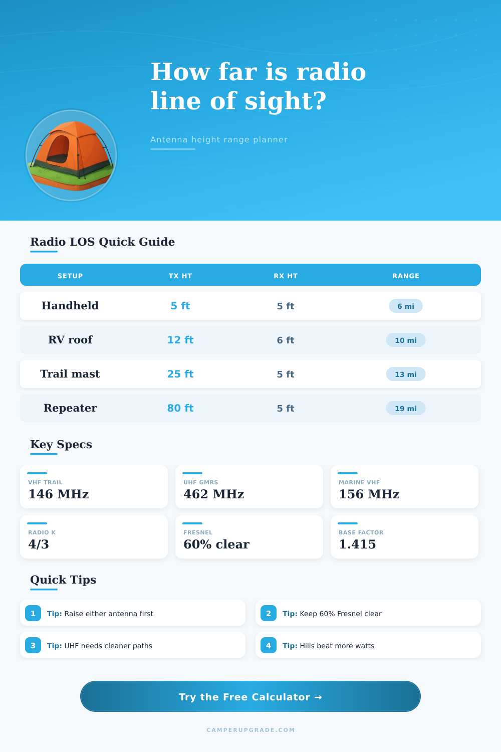
| Two antenna heights | Optical horizon | Radio K 4/3 horizon | Typical camp planning range |
|---|---|---|---|
| 5 ft to 5 ft handhelds | 5.5 mi / 8.8 km | 6.3 mi / 10.2 km | 3.5 to 5 mi |
| 12 ft RV roof to 5 ft handheld | 7.0 mi / 11.3 km | 8.1 mi / 13.0 km | 5 to 7 mi |
| 25 ft mast to 5 ft handheld | 8.9 mi / 14.3 km | 10.2 mi / 16.4 km | 6 to 9 mi |
| 80 ft repeater to 5 ft handheld | 13.8 mi / 22.2 km | 15.9 mi / 25.5 km | 10 to 14 mi |
| Frequency band | Common outdoor use | Fresnel sensitivity | Planning note |
|---|---|---|---|
| 146 MHz amateur VHF | Trail, SAR, simplex | Wider Fresnel zone | Needs more path width, bends slightly better around terrain. |
| 156 MHz marine VHF | Boats, shore, kayak | Wider Fresnel zone | Open water paths often match the horizon estimate closely. |
| 462 MHz GMRS | Camp, convoy, family | Moderate Fresnel zone | Good portable choice when trees and vehicles are managed. |
| 915 MHz tracker | Telemetry, mesh, sensors | Narrower zone | Cleaner line of sight matters more than transmitter power. |
| Terrain profile | Range factor | Clearance allowance | Use when |
|---|---|---|---|
| Clear water or salt flat | 100% | 0 mi | Boat, shoreline, dry lake bed, beach. |
| Open desert or prairie | 92% | 0.5 mi | Mostly clear ground with low brush. |
| Rolling campsite terrain | 82% | 1.5 mi | Small terrain folds, RVs, tents, light tree lines. |
| Dense forest or canyon | 58% | 5 mi | Heavy trees, walls, side canyons, blocked takeoff angles. |
| Mount option | Typical height | Range gain vs handheld | Setup tradeoff |
|---|---|---|---|
| Handheld at face level | 5 ft / 1.5 m | Baseline | Instant, but body and terrain block the path. |
| Vehicle roof antenna | 9 to 13 ft / 2.7 to 4 m | About 25% to 40% | Better horizon and ground plane, still vehicle dependent. |
| Portable camp mast | 20 to 30 ft / 6 to 9 m | About 60% to 90% | Strong campsite improvement with guy lines and clear space. |
| Hilltop or tower site | 60 ft+ / 18 m+ | Often 150%+ | Dominated by terrain access and safe mounting. |
This is a good example: You’re on a ridge and can see your receiver. Since you can see it, you figure radio will also reach you. However, there’s usually something wrong with that logic. The radio horizon for signal transmission isn’t the same as visual horizon for light reception. Radio waves curves ever so slightly when encountering the atmosphere, extending their effective range past what human eye can see.
That’s why most camping communications plans is doomed to failure; they account only for line-of-sight reception. Atmospheric refraction and antenna height are both included in the calculation, making it a real-world estimate of that unseen horizon instead of simply a guess at line of sight. This equation has a single most powerful variable, and that’s the height of the antenna. It matter more than the power output from the transmitter.
Why Height Matters More Than Power for Radio Range
You could double your watts and barely get any additional range if you’re trying to send the signal over a hill or through some trees; raise the antennae just a few feet, however, and you’ll be able to clear right past them. There’s also a factor called the effective earth radius factor which typically defaults to 4/3, modeling what happens to the wave as it interacts with normal atmospheric conditions (i.e. (i.e., it bends toward the ground). This will have different impacts depending on frequency (VHF versus UHF). It is not as strong for the UHF frequencies used by GMRS or FRS radio, but it is still enough to greatly increase the effective range beyond what would be expected based purely on optics alone. In flat country, that’d translate to maybe a mile or two difference in expected range.
But that’s not how terrain works. The horizon isn’t a nice equation in a textbook. Buildings, rocks, trees don’t care about theory; they gets in the way. That’s why there’s also a terrain profile drop-down on the calculator that factors in how much that might reduce your actual range based off a little fudge factor for reliability. Open desert will maintain nearly all signal, while dense woods may reduce your range by as much as 40% (because plants absorb it and the straight-line path is blocked). That really matters when you’re making plans out in the real world. It takes an abstract math figure and turns it into a practical estimate of where you can actualy hold a conversation.
Then there’s the Fresnel zone that most recreational users fail to account for. It’s an invisible, imaginary oval volume around the straight-line path between the two antennas. Even if you have a clear line of sight, any object like a shoulder or ridge that cuts into the Fresnel zone will greatly reduce its effectiveness. The calculator determines how much air space must remain free to maintain a 60-percent cut at the edge of this zone. Simply having line-of-sight won’t be enough; you’ll get spotty reception with trees or ridge shoulders cutting into the edges of the zone. Lifting the ends of the link typically improves performance more effective than increasing power.
If you’re arranging a group outing, begin with your worst-case scenario. What’s the effective horizon for someone who holds his radio waist-high? That can change drastically by pairing that with a portable mast or even a vehicle roof mount. And the elevation tables on the page will show just how fast range increases with every foot of elevation. Not because they have “better” gear, but because an 80-foot repeater site is up and out of local clutter, while a five-foot handheld isn’t.
Never trust the max distance because weather changes things. On rare occasions, atmospheric ducting will extend line-of-sight by hundreds of miles. Other times, temperature inversions will trap signals close to the surface or bounce them back up and away. Stick to what’s reasonable. The middle-ground. With the input numbers, select a distance that has proven communications, not “could” communicate. If the margin is too small, move to a higher spot or pick another site. Better to be right and have a little wiggle room than find out you’re blocked when you need signal.
It’s basically variable geometry. Where do I put my antenna? What’s between it and other stations? What’s between me and the listeners? I can’t predict weather, or the terrain… But I could of managed the height and clearance if those are planned for from the beginning, and not thought of afterwards. Unpredictable radio wave movement becomes manageable.
Let the math handle the curves and coefficients, and then you can focus on where to place your antenna. Then think about placement. The horizon is your friend once you figure that out. You won’t have to guess anymore. It is just about position. This is what makes all the difference in going from silence to a clear channel.