Compass Declination Calculator
Update declination from map epoch, convert true and magnetic bearings, and model drift risk from heading error over distance.
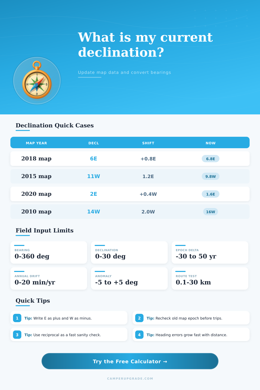
🧭Declination Scenario Presets
⚙Bearing And Declination Inputs
📊Declination Control Grid
📘Reference Tables
| Declination Band | Magnitude | Field Risk | Recommended Cadence |
|---|---|---|---|
| Low | 0-3 deg | Small route bias | Check per season |
| Moderate | 4-10 deg | Visible drift | Check every trip |
| High | 11-18 deg | Major route miss | Check each leg |
| Very High | 19+ deg | Critical correction | Dual confirmation |
| Annual Shift Rate | 5 Year Change | 10 Year Change | 15 Year Change |
|---|---|---|---|
| 2 min/yr | 0.17 deg | 0.33 deg | 0.50 deg |
| 4 min/yr | 0.33 deg | 0.67 deg | 1.00 deg |
| 6 min/yr | 0.50 deg | 1.00 deg | 1.50 deg |
| 8 min/yr | 0.67 deg | 1.33 deg | 2.00 deg |
| Input Type | Declination | Formula | Example Output |
|---|---|---|---|
| True 120 | 8E | M = T - D | 112M |
| True 120 | 8W | M = T - (-D) | 128M |
| Mag 250 | 6E | T = M + D | 256T |
| Mag 250 | 6W | T = M - D | 244T |
| Heading Error | Drift at 1 km | Drift at 3 km | Drift at 5 km |
|---|---|---|---|
| 1 deg | 17 m | 52 m | 87 m |
| 2 deg | 35 m | 105 m | 175 m |
| 5 deg | 87 m | 262 m | 437 m |
| 10 deg | 176 m | 529 m | 881 m |
Compass declination shows the difference between true north and magnetic north. It is the angle between the direction to geographic North Pole and the position that points the compass needle. Navigators suffered because of this magnetic problem for centuries
Currently magnetic north is in Canada, around 100 miles from the North Pole. Because it always moves, the declination adjusts according to place and time, following the magnetic changes in the Earth core.
What Is Compass Declination?
There is a line where geographic and magnetic north poles meet, so there is no declination here. Zero declination is present in central United States, north Africa, India, China and most part of Europe. East of that line the magnetic pole moves the compass needle west of true north, which gives west declination.
If magnetic north is east of true, the needle twists right, positive declination. West it twists left, negative declination.
When compass shows 60 degrees with -8 degrees west declination, real course is 52 degrees regarding true north. Mistakes in those calculations double the declination. To use field orientation on a map or vice versa, you must correct every diffrence.
Compasses for hiking, as those with base or protractor, have a rotating dial of 360 degrees, independent of the magnetic needle. For set declination to true north, you turn the dial until the right number of degrees are between north mark and magnetic indication of the needle tip. Compass with declination screw eases everything.
Join it to the map, and all courses will be true, matching the map, no need for declination.
Declination values appear on topo maps. In the right margin stands a little triangular diagram with average declination for the map center. In clear night, turn the dial to Polaris for true north, and the needle swings show magnetic declination.
Bad compasses get bubbles and become useless, so it is worth buying a quality compass.