Cloud Base Calculator
Estimate cloud ceiling AGL and MSL from air temperature, dew point spread, and terrain elevation.
☁Quick Weather Presets
⚙Atmospheric Inputs
📊Sky Planning Snapshot
📘Reference Tables
| Dew Point Spread | Cloud Base AGL | Cloud Class | Field Implication |
|---|---|---|---|
| 2 F / 1.1 C | 444 ft / 139 m | Very low | Frequent fog and low stratus risk |
| 5 F / 2.8 C | 1111 ft / 339 m | Low | Low deck likely in humid terrain |
| 8 F / 4.4 C | 1778 ft / 542 m | Moderate | Usable clearance in open ground |
| 12 F / 6.7 C | 2667 ft / 813 m | Higher base | Better vertical clearance window |
| 16 F / 8.9 C | 3556 ft / 1084 m | High base | Dry air with elevated cloud deck |
| Station Elevation | Base AGL | Cloud Base MSL | Terrain Note |
|---|---|---|---|
| 250 ft MSL | 1200 ft | 1450 ft MSL | Lowland routes keep broader margin |
| 1200 ft MSL | 1200 ft | 2400 ft MSL | Rolling hills need route checks |
| 2800 ft MSL | 1200 ft | 4000 ft MSL | Passes may touch cloud base |
| 4500 ft MSL | 1200 ft | 5700 ft MSL | Plateaus lose vertical margin fast |
| Scenario | Temp / Dew Pt | Modeled AGL | Planning Outcome |
|---|---|---|---|
| Humid valley dawn | 64 / 61 F | 666 ft | Expect low ceiling pockets |
| Dry interior noon | 95 / 42 F | 11778 ft | High base and strong mixing |
| Coastal marine layer | 66 / 63 F | 666 ft | Persistent low deck likely |
| Mountain summer pass | 74 / 48 F | 5772 ft | Good clearance but monitor storms |
| After frontal rain | 68 / 64 F | 888 ft | Clouds can rebuild quickly |
| Conversion | Factor | Example Input | Example Output |
|---|---|---|---|
| F to C | (F - 32) x 5/9 | 68 F | 20 C |
| C to F | (C x 9/5) + 32 | 10 C | 50 F |
| Feet to meters | ft x 0.3048 | 1500 ft | 457.2 m |
| Meters to feet | m x 3.28084 | 600 m | 1968.5 ft |
| Cloud base rule | 125 m per C spread | 4 C spread | 500 m AGL |
The height of the cloud base is the altitude at which the clouds begin to form. This measurement is critical for the person hiking in mountain terrain. If the height of the cloud base is low, it means that the clouds will be close to a ground.
In extreme cases, the low height of the cloud base can result in a whiteout condition for the hiker. To understand the relationship between air temperature and the dew point, a person can calculate the height of the cloud base. The air temperature is the temperature of the air.
How to Calculate Cloud Base Height for Hiking
The dew point is the temperature at which the air becomes saturated with moisture. The difference between these two measurement is called the spread. The spread determine the height at which the moist air will rise until it becomes saturated with moisture and form clouds.
As the warm air begins to rise from the ground, the air begins to cool. The air will cool until it reaches the dew point. At this temperature, the air will become saturated with moisture and form cloud at this altitude.
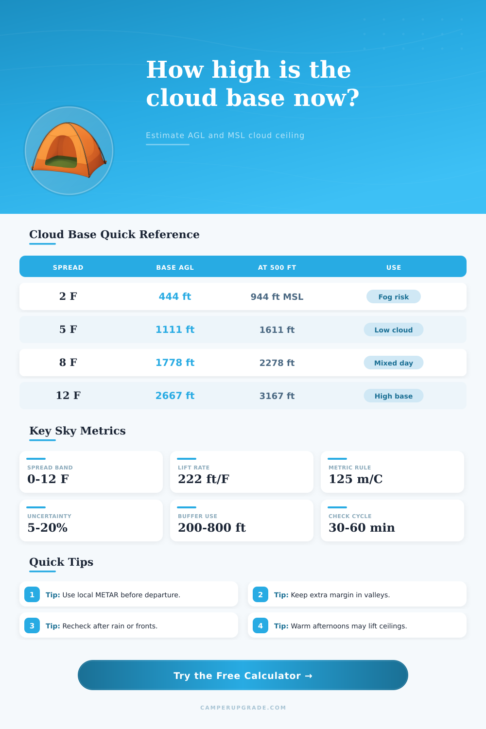
In imperial units, for each degree of spread in the air temperature and dew point measurement, the height of the cloud base will rise 222 feet. If the spread between the air temperature and the dew point is 2 degrees, the height at which the clouds will form will be 400 feet above the ground. If the spread is 12 degrees, the height at which the clouds will form will be at 2,664 feet above the ground.
If the spread of the air temperature and dew point is larger, the clouds will form at a more higher altitude above the ground. This measurement will provide more clearance for the person hiking over the mountain ridge. Terrain can impact the height at which the clouds form.
When calculating the height of the cloud base, a person must account for the terrain. Weather station might be situated at sea level. However, the pass that the person wants to hike over mountains might be at a higher elevation.
In this case, the person will have to add the elevation of the location that they are hiking to the height of the cloud base measurement to calculate the true altitude of the clouds above sea level. Due to the terrain, the height of the cloud base might change. For instance, valley have pools of cold air settling on the terrain.
These pools of cold air will cause the height of the cloud base to be lower than the measurements provided by the weather models. In these situation, a person will incorporate a larger safety buffer into the calculations of the height of the cloud base. There are presets for the various weather scenarios.
However, the person hiking in the mountains must also account for the uncertainty of the weather forecast. Presets determine the settings for the various weather scenarios. Weather forecasts have an uncertainty of 5 to 20 percent.
A person can account for this percentage using an uncertainty input in the calculation of the height of the cloud base. If the calculation of the height of the cloud base result in a negative number, it means the clouds will be below the elevation that the person would like to hike to. In this case, a negative number would indicate that the person should not go on there hike.
The weather should be rechecked every 30 to 60 minutes. The weather will not remain the same throughout the hike. Areas with moisture such as rivers will produce fog in the valleys.
This fog will lower the height of the cloud base. The sun will heat the ground. The heated ground will warm the air above the ground.
As the air warms, it will rise. When the air reaches the dew point at a higher altitude, it will become saturated with moisture and form clouds. The same weather scenario will happen if a person begins their hike after a rain event in the area.
In this case, the clouds will begin to rebuild in the mountains. The moisture in the mountains will cause the height of the cloud base to drop to the ground. To summarize, the spread between the air temperature and the dew point will determine the height of the cloud base.
The spread will be multiplied by 222 to determine the height of the cloud base. The current elevation will be added to the height of the cloud base to account for the terrain. A person will then subtract a safety buffer from the height of the cloud base to ensure that there is enough clearance for the person hiking on the mountain ridges.
These calculations will have to be performed frequently because the air temperature, the dew point, and the terrain might change throughout the hike.