Magnetic to True Heading Calculator
Convert a magnetic or compass heading into a true heading, updated magnetic variation, grid bearing, reciprocal heading, and signed correction for boating, trail navigation, overlanding, aviation-style planning, and map-and-compass checks.
🧭Real Heading Correction Presets
⚙Heading, Declination, Deviation, and Grid Inputs
This calculator handles heading math only. For safety-critical navigation, verify against current charts, local notices, and a second navigation method.
📊Heading Math Spec Grid
📘Reference Tables
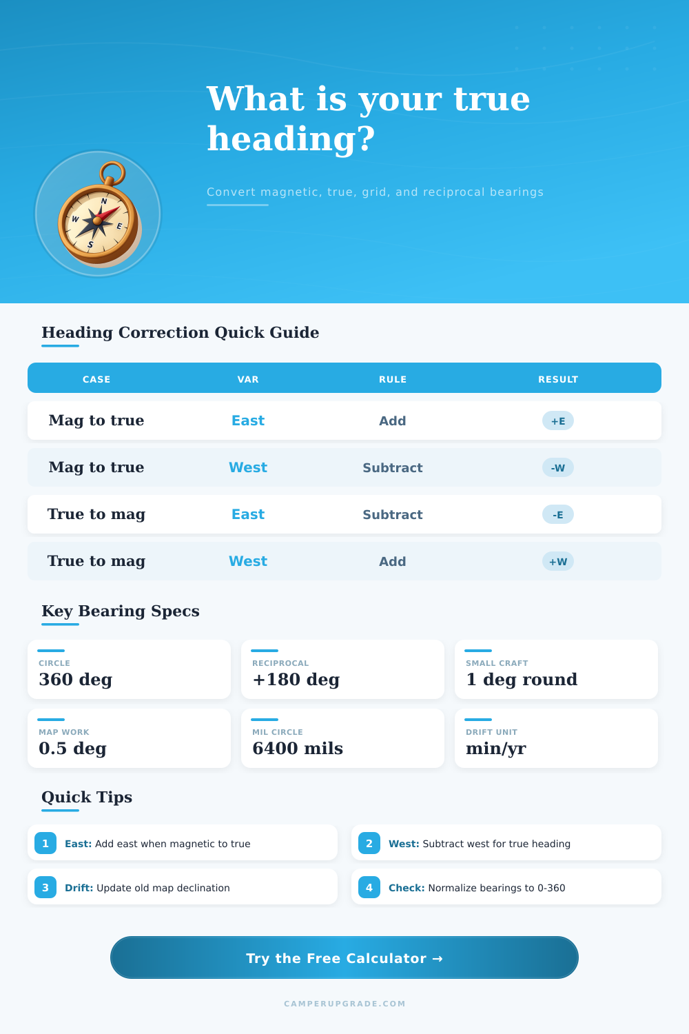
| Conversion | East value | West value | Memory rule |
|---|---|---|---|
| Magnetic to true | Add east | Subtract west | True = magnetic + signed variation |
| True to magnetic | Subtract east | Add west | Magnetic = true - signed variation |
| Compass to magnetic | Add east deviation | Subtract west deviation | Only when starting from compass heading |
| True to grid | Subtract east convergence | Add west convergence | Grid = true - signed convergence |
| Use case | Typical rounding | Check interval | Note |
|---|---|---|---|
| Hand compass trail leg | 1 to 5 degrees | Every leg | Terrain and sighting error often dominate. |
| Small boat steering | 1 degree | Every course change | Use current chart variation and deviation card. |
| Overland vehicle azimuth | 1 degree | After mounting gear | Dash electronics can shift compass readings. |
| Map grid plotting | 0.5 degree | When changing map sheet | Grid convergence varies by location. |
| Region example | Variation feel | Planning impact | Field cue |
|---|---|---|---|
| Pacific Northwest | Large east | True heading can be 14 to 16 degrees higher | Do not skip correction on long water crossings. |
| Maine coast | Large west | True heading can be 14 to 18 degrees lower | Fog routes need careful chart work. |
| Central Rockies | Moderate east | Often 6 to 10 degrees higher | Visible landmarks help catch sign errors. |
| South Australia | Moderate east | Often 6 to 9 degrees higher | Update older printed maps before trips. |
| Heading | Reciprocal | Quadrant | Common description |
|---|---|---|---|
| 000 degrees | 180 degrees | North/South | Northbound or return southbound |
| 045 degrees | 225 degrees | NE/SW | Diagonal route leg |
| 090 degrees | 270 degrees | East/West | Crossing or shore-parallel line |
| 135 degrees | 315 degrees | SE/NW | Back bearing reverses quadrant |
💡Practical Navigation Tips
Magnetic variation are the angle between magnetic north and true north at a specific location on the Earth. Magnetic variation differ from location to location, and the variation change over time due to the shifting magnetic field of the planet. Many map and charts include the magnetic variation value for a specific year that the map was printed.
If the map is several years out of date, the magnetic variation on the chart may no longer be accurately. Individuals must account for the change in magnetic variation from the year of the maps publication. By entering the magnetic variation and the annual drift rate of the Earths magnetic field into a calculator, individuals can determine the current magnetic variation at a specific location.
Magnetic Variation and Compass Deviation
Compass deviation is another type of error in the magnetic variation reading. The boat itself causes compass deviation rather than the Earths magnetic field. All metal component in the boat, such as the boats engine or electrical components, can impact the magnetic field that the compass measure.
This shift in the compass needle is call compass deviation. When using a calculator, individuals can set the source of the heading to the compass rather than the magnetic field. By doing so, the reading of the magnetic variation will reflect the compass deviation.
By entering both the compass deviation and the magnetic variation, individuals can find the true heading of the object being measure. Reciprocal heading are used to determine the back bearing of an object. To find the back bearing of an object, individuals must add 180 degree to the current heading of the object.
That number can be wrapped around a circle that range from 0 to 360 degrees. Calculators will make this calculation automatic and save the individual from having to perform this calculation while on the boat. Grid bearings is another type of measurement that individuals can encounter on many maps.
Most maps will display grid north rather than true north. The difference between the two type of north is called convergence. In some area, the difference between grid and true north is close to zero.
In other areas, the difference in magnetic variation can be several degree. By entering the value for convergence in a calculator, the calculator will produce the grid bearing that match the lines printed on the map. This bearing can be used for plotting a course on the paper map.
The degree of precision that individuals require for the heading will depend on the specific task that they are to complete. For instance, individuals walking on a trail may be tolerant of a small error in the heading, such as one or two degree. Small boat and overland travel routes, however, require more precision in the heading measurement because even small error in heading will travel further as the distance traveled increase.
By setting the degree of rounding on the calculator to the degree of precision required for the specific task, the individual can ensure that they have the correct level of precision for that task. Magnetic variation change every year due to the annual drift of the Earths magnetic field. Magnetic variation printed on a chart that was printed in 2021 will no longer be accurately in 2026.
That printed value will be five years out of date. By entering the annual drift value and the number of year between the creation of the chart and the desired date, the calculator can provide the individual with the updated magnetic variation. Without adjusting for the annual drift rate, individuals will be using an outdated value for magnetic variation.
This value will not match magnetic variation at the present time. The same can be said for many route card or GPS tracks. The magnetic variation for the track printed on the route card may be several degree different than the magnetic variation at the current time.
The individual must recalculate the printed value using the most up-to-date magnetic variation drift rate. By updating the magnetic variation drift rate on a route card or saved GPS track, the individual ensure that their route information is still accurate. It also prevent them from using out dated information from printed route cards.
Individuals must use more than just the calculator to navigate. Individuals must cross check the calculated true heading with the GPS or other landmark. The calculator will make sure that the calculations are accurate and prevent the individual from making an error in the measurement of east or west heading.
However, the calculator will never replace an individuals knowledge of the area that is being travel in. By using the calculator to find the heading that the boat should travel to reach the destination, the individual ensure that the boat will remain in safe water.