Tide Height Calculator
Predict tide level at your target time using observed high and low water inputs, station offsets, and two forecast curve models.
🌊Launch And Crossing Presets
⚙Tide Height Inputs
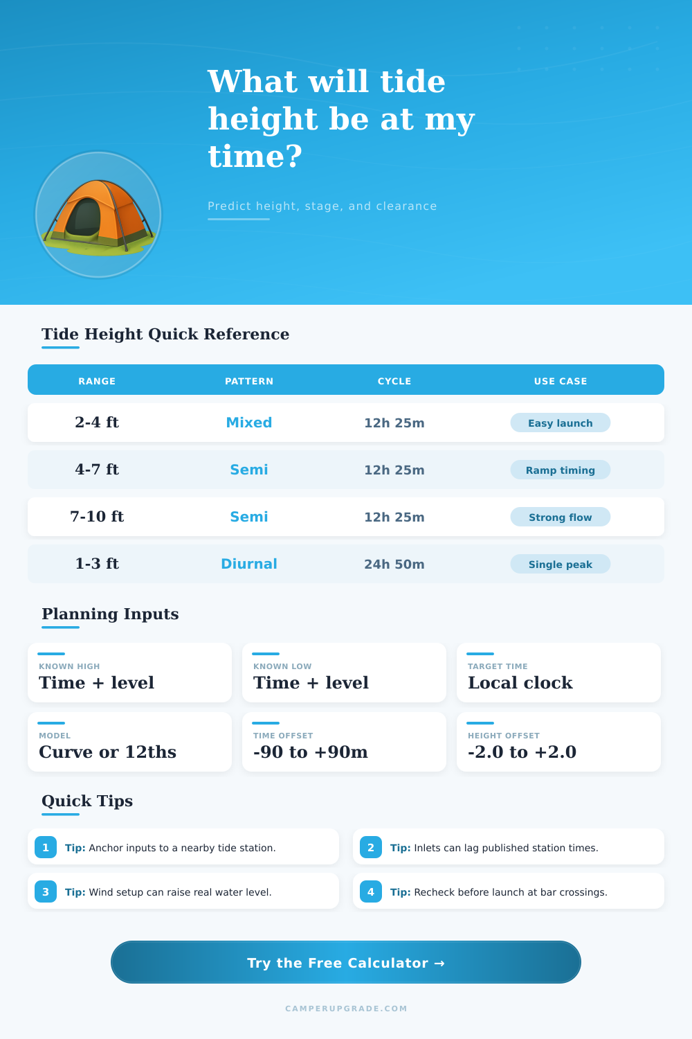
📊Tide Pattern Benchmarks
📘Reference Tables
| Pattern | High To Low Span | Low To High Span | Best Use |
|---|---|---|---|
| Semidiurnal | 6h 12m | 6h 12m | Most open coasts |
| Mixed Semidiurnal | 5h 30m to 7h | 5h 30m to 8h | Bays and estuaries |
| Diurnal | 12h 25m | 12h 25m | Some gulf stations |
| Current Inlet | Site measured | Site measured | Narrow passes |
| Hour From High | Rule Of Twelfths | Cumulative Change | Percent Of Range |
|---|---|---|---|
| Hour 1 | 1/12 of range | 1/12 | 8.3% |
| Hour 2 | 2/12 of range | 3/12 | 25.0% |
| Hour 3 | 3/12 of range | 6/12 | 50.0% |
| Hour 4 | 3/12 of range | 9/12 | 75.0% |
| Hour 5 | 2/12 of range | 11/12 | 91.7% |
| Hour 6 | 1/12 of range | 12/12 | 100% |
| Feet | Meters | Feet | Meters |
|---|---|---|---|
| 1.0 ft | 0.305 m | 6.0 ft | 1.829 m |
| 2.0 ft | 0.610 m | 8.0 ft | 2.438 m |
| 3.0 ft | 0.914 m | 10.0 ft | 3.048 m |
| 4.0 ft | 1.219 m | 12.0 ft | 3.658 m |
| Activity | Typical Draft | Suggested Margin | Target Clearance |
|---|---|---|---|
| Kayak launch | 0.6 ft | 0.8 ft | 1.4 ft |
| Skiff ramp | 1.0 ft | 1.2 ft | 2.2 ft |
| Cruiser slip | 2.5 ft | 1.5 ft | 4.0 ft |
| Bar crossing | 2.0 ft | 2.0 ft | 4.0 ft |
Tidal height points the height above the Mean Lower Low Water (MLLW). This MLLW is the daily low tidal level during 19 years. It does not show, as far as high the water will climb on the coast.
The tidal heights appear in feet above or under MLLW. Projected tides come from models that foresaw them. Observed tides mark what sensors lodge just now.
Tides and Beach Safety
Tidal range measures the difference between high and low tide. The most coastal places have two high and two low tides daily, but commonly you receives only one from each for day.
The tidal height depends of the latitude and of the form and size of bays. Everything that matters especially at bays with tiny channels that binds them to the sea. The mainstream factors for tidal height and hour is the positions of sun and moon regarding us.
While perigee, when moon most proksimas the Earth, happen perigeaj printempaj tides that surpasses the normal. While apogee, when it most malproksimas the tidal range declines. Know the lunar influence to tidal heights help plaĝanojn prepare for altering maritime states.
As far as long the water climbs on beach that decides the slope of the beach. Dekpieda tide does the water ten feet deeper. But it does not move the akvlinion ten feet more upward than during low tide.
Tidal height and hour matters for amusing and commercial conclusions on water likewise as for manage inundrikojn. For high tidal times of the forthcoming week use interactive charts. For tidal predictions of stations search according to name code or latitude and lengths.
Here you find local aquatic levels tides current predictions and oceanographic and meteorological data. If you bear tendilon in rucksack the vojlisto say that ensure you during low tide. Only then it is possible it erect for distinctly evident reasons.
During camping at beach well plan according to tide. Sharply tendi on beach can end by means of submersa tent in the morning. Do plaĝajn fires only under the high tidal line.
At broad open beach for wild camping look at line of driftlegomoj seaweeds and garbages. This shows until where comes the water. Erect the fire above that line so that it do not wash away.
If tide arrives and you fire meze of the beach maybe will lack time rostadi marshmallows. More well build it under the projected high tajdlinio. At plaĝa tendumadejo use already existent homes for your fire.
Because fires no permesatas on parks or private territories they must be under the high tajdlinio.