Hiking Time Calculator
Estimate moving duration, total trail time, and ETA from distance, elevation, terrain, and break strategy.
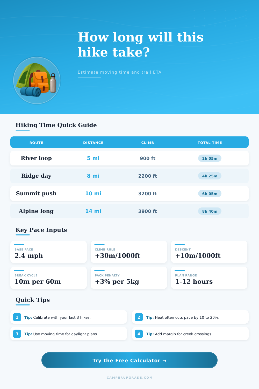
🥾Quick Trail Presets
⚙Route And Pace Inputs
📊Pacing Reference Grid
📘Reference Tables
| Trail Surface | Suggested Factor | Pace Effect | Route Profile |
|---|---|---|---|
| Graded dirt path | 0.90x | Fastest travel | Rail trail and park loops |
| Mixed singletrack | 1.00x | Baseline model | Most maintained trails |
| Rock and root | 1.12x | Step control needed | Mountain forest terrain |
| Loose or scree | 1.25x | Slower footing | Dry gullies and ridges |
| Scramble sections | 1.35x | Hands-on movement | Steep exposed sections |
| Elevation Gain | Ascent Penalty | Descent Penalty | Added Time Total |
|---|---|---|---|
| 1000 ft | 30 min | 10 min | 40 min |
| 2000 ft | 60 min | 20 min | 1h 20m |
| 3000 ft | 90 min | 30 min | 2h 00m |
| 4000 ft | 120 min | 40 min | 2h 40m |
| Distance | Flat Time @2.4 mph | With +1500 ft Gain | With Breaks (10m/hr) |
|---|---|---|---|
| 4 miles | 1h 40m | 2h 25m | 2h 49m |
| 6 miles | 2h 30m | 3h 15m | 3h 47m |
| 8 miles | 3h 20m | 4h 05m | 4h 46m |
| 10 miles | 4h 10m | 4h 55m | 5h 44m |
| Preset Scenario | Distance | Elevation Gain | Modeled Total Time |
|---|---|---|---|
| City Park Loop | 4.2 mi | 350 ft | 1h 58m |
| Forest Half Day | 7.1 mi | 1500 ft | 3h 57m |
| Steep Ridge Push | 8.8 mi | 2800 ft | 5h 34m |
| Summit Day Hike | 11.3 mi | 3600 ft | 7h 18m |
Rating of the involved time for rise forms basic element of good planning. You count this for know how many hours or days must elpasi for end the march. Various modes help to do such rating.
The Naismith-rule gives simple mode reach minimal time for climbing. It estimates horizontan distance in miles shared by means of three pluse rise in feet shared by means of 2000. For instance 6-mejla way with 2000 feet of alteca prize requires 3 hours.
How to Estimate Hiking Time
Libra-time is other access that well estimates mountainous and rocky paths. It considers 30 minutes for mile and 30 minutes for every 1000 feet of rise rounding to the nearest kvinto of hour.
Vertical distance also requires attention. You method forces to add one hour for around 300 metres of height. For 1200 metres of rise it would give 4 hours except the time for descent.
Some uses fingroregulon of 2 miles for hour on flat way and 1 mile for hour below later add 1 hour for every 1000 feet of alteca prize. Other rating memorigas 2 miles for hour and duonhoron for 1000 feet up but only 2 miles for hour below. Here no aldoniĝas time for height in descent.
Like this can rezultati 5,5-hora rating.
Terrain and personal provisions determine the pace. Different terenaĵoj affect the haste during rise. Level of arrangement also decides the sustainable bit long-range.
On flat path well prepared pedestrian with lightweight burden reach 15 until 20 minutes for mile. Intermediate pace commonly is 2,5 miles for hour although it slows to 2 miles for hour up and quicken to 3 below. Walking bit variiĝas according to provisions.
For fast rises one plan 3 miles for hour for centres 2 and for slow 1. That is only general guide. It must adapt to malegala terrain pauses arrangement and weariness.
Heavy pakŝarĝo like that. Even 50-kilometra march can end in 11,5 hours.