🛤 Trail Difficulty Rating Calculator
Enter your trail details to get a comprehensive difficulty score and rating from Easy to Expert.
| Factor | Condition | Points Added | Notes |
|---|---|---|---|
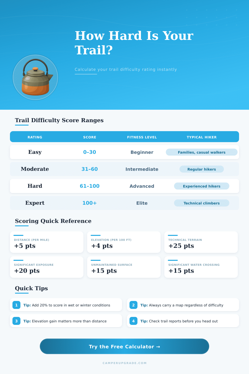
| Distance | Per mile (or 1.6 km) | +5 pts | Cumulative fatigue factor |
| Elevation Gain | Per 100 ft (30 m) | +4 pts | Most critical factor |
| Terrain | Paved / Gravel | +0 pts | Easiest surface |
| Terrain | Dirt / Packed | +5 pts | Standard trail |
| Terrain | Rocky | +15 pts | Footing challenge |
| Terrain | Technical / Scrambling | +25 pts | Hands required |
| Surface | Well-Maintained | +0 pts | Clear path |
| Surface | Moderately Maintained | +8 pts | Some route-finding |
| Surface | Unmaintained / Bushwhack | +15 pts | Navigation skill needed |
| Exposure | None | +0 pts | No fall hazard |
| Exposure | Some (cliffs/drops) | +10 pts | Acrophobia factor |
| Exposure | Significant | +20 pts | High consequence |
| Water Crossings | None | +0 pts | Dry route |
| Water Crossings | Small / Easy | +5 pts | Rocks or log |
| Water Crossings | Significant | +15 pts | Wet feet likely |
| Trail Name | Distance | Elev Gain | Rating | Score |
|---|---|---|---|---|
| Appalachian Trail (day section) | 8 mi | 1,200 ft | Moderate | ~56 |
| Half Dome, Yosemite | 17 mi | 4,800 ft | Expert | ~147 |
| Angels Landing, Zion | 5.4 mi | 1,488 ft | Hard | ~97 |
| Mount Whitney Trail | 22 mi | 6,100 ft | Expert | ~164 |
| Bright Angel Trail (rim to river) | 9.5 mi | 4,380 ft | Hard | ~87 |
| Wonderland Trail, Rainier | 93 mi | 22,000 ft | Expert | ~490+ |
| Grinnell Glacier, Glacier NP | 11 mi | 1,600 ft | Moderate | ~58 |
| Longs Peak, Rocky Mtn NP | 15 mi | 5,100 ft | Expert | ~148 |
Trail difficulty ratings have their benefit. They help hikers estimate which ways match their fitness and skills. Every year more than 200 cases of avoidable or serious injuries happen in parks and nature reserves and many from them could be avoided, if one simply would choose ways according to their abilities.
The cause is simple: match the way to your experience, and you will be safer, while you enjoy the time here.
How Trail Difficulty Ratings Work
Here the main problem even so, there is no one universal standard, that counts everywhere. Skiing has its color-coded system for slopes, and whitewater kayakers use the ratings of the American Whitewater Association. What about trails?
Not the same. Most trails in mountains do not have any rating system, and those, that have, do not follow the same rules.
When ratings appear, they usually relate to ways in a particular area. The most common categories are easy, intermediate and difficult. Easy ways are short; imagine one to two miles, with flat, simple soil and almost no height change.
Intermediate ways extend a bit more, between two and four miles, with some visible hills. If it is challenging, expect four miles or more, with heavy terrain everywhere. Some systems split it into four levels, adding “advanced” and “exhausting” to the list.
There are even special ratings for hikers with disabilities, that access the trail entirely differently.
If a trail points its length, that always includes the whole round trip. The real difficulty rating depends on several things, how rough the soil is, how sharp the slope, the total height change upward and down, and physical obstacles like rocks, roots, sudden slopes or slippery steels. Also matters the width of the way, the whole distance and the type of surface, on which one walks.
Many state or federal services… Including USFS and BLM, borrow the ski model. Green circles show the easiest ways, blue squares point to medium challenge, and black diamonds signal the most hard parts.
Mountain bikers apply something similar using the IMBA Trail difficulty rating System. In some places one separates the technical challenge from the physical effort, presenting them as two separate pieces of information.
Here is wear everything becomes unclear: those difficulty ratings are very subjective. A trail that seems easy for an expert hiker could be a disaster for a newcomer. Sometimes the ratings stress rough, technical soil more than steepness, although big hills exhaust folks during fast descents.
The ratings assume, that the trail is well kept, and leave the rest to the opinion of the hiker. Notably, ratings compare ways between themselves in the same region, not across various places. A hard trail in one park could seem simple compared to tough trailssomewhere else.
Length alone says almost nothing useful. Height change, the shape of the height profile and the state of the trail surface, these details truly matter. A rough rule of thumb suggests one third of an hour for every mile, plus another third for every thousand feet of height gain.
Checking all those things before you go does make a real difference.