🧭 Pacific Crest Trail Distance Calculator
Calculate PCT segment distances, daily mileage targets, and trip duration for any section of the trail
1,130 km
1,536 km
692 km
805 km
4,270 km
128,000 m
Forester Pass
Duration
| Daily Miles | Daily Km | Full PCT Days (hiking) | With 15 Zero Days | Pace Type |
|---|---|---|---|---|
| 10 mi | 16.1 km | 266 days | 281 days | Beginner |
| 12 mi | 19.3 km | 221 days | 236 days | Beginner+ |
| 15 mi | 24.1 km | 177 days | 192 days | Average |
| 17 mi | 27.4 km | 156 days | 171 days | Average |
| 20 mi | 32.2 km | 133 days | 148 days | Strong |
| 23 mi | 37.0 km | 115 days | 130 days | Strong+ |
| 25 mi | 40.2 km | 106 days | 121 days | Ultralight |
| 30 mi | 48.3 km | 88 days | 103 days | Fast Packer |
| Landmark | NOBO Mile | Km Mark | State |
|---|---|---|---|
| Southern Terminus (Campo) | 0 | 0 km | CA |
| Mount Laguna | 41 | 66 km | CA |
| Big Bear Lake | 266 | 428 km | CA |
| Tehachapi (Mojave) | 566 | 911 km | CA |
| Kennedy Meadows (Sierra Start) | 702 | 1,130 km | CA |
| Forester Pass (Highest Pt.) | 780 | 1,255 km | CA |
| Tuolumne Meadows (Yosemite) | 942 | 1,516 km | CA |
| South Lake Tahoe | 1,092 | 1,758 km | CA |
| Sierra City | 1,195 | 1,923 km | CA |
| Oregon Border (Seiad Valley) | 1,656 | 2,665 km | CA/OR |
| Crater Lake | 1,821 | 2,931 km | OR |
| Washington Border | 2,147 | 3,455 km | OR/WA |
| Snoqualmie Pass | 2,393 | 3,851 km | WA |
| Northern Terminus (Manning Park) | 2,653 | 4,270 km | WA/BC |
| Miles | Kilometers | Feet | Time at 17 mi/day |
|---|---|---|---|
| 1 mi | 1.609 km | 5,280 ft | ~1.4 hrs (3 mph) |
| 10 mi | 16.09 km | 52,800 ft | ~3.3 hrs (3 mph) |
| 50 mi | 80.5 km | 264,000 ft | 2.9 days |
| 100 mi | 160.9 km | 528,000 ft | 5.9 days |
| 500 mi | 804.7 km | 2,640,000 ft | 29.4 days |
| 1,000 mi | 1,609 km | 5,280,000 ft | 58.8 days |
| 2,653 mi | 4,270 km | 14,007,840 ft | 156 days |
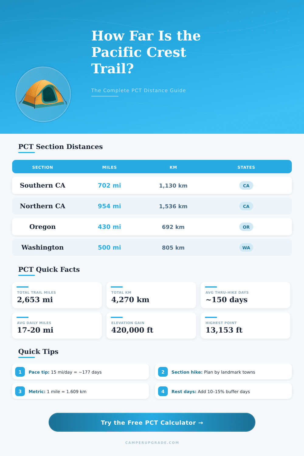
The Pacific Crest Trail, usually called the PCT, ranks among the most remarkable hiking adventures on Earth. It extends for around 2 650 miles from the Mexican border in California to the Canadian border in Washington. The path follows the highest sections of the Cascade and Sierra Nevada mountains, that sit between 100 and 150 miles east of the American Pacific coast.
It crosses three states: California, Oregon and Washington. Compared to other known paths it covers fewer regions. For instance, the Continental Divide goes across seven states, while the Appalachian Trail sits in fourteen.
The Pacific Crest Trail: A Long Hike from Mexico to Canada
The south starting point sits a bit north of the wall along the American-Mexican border, in a place called Campo. The land right south of that monument belongs now to National Forest, and public access ends beside barbed wire fence only some feet ahead. The whole Distnace of the way changes yearly, to create space for nice views and to improve the path.
To cover the whole thing requires a lot of time. With 20 miles daily, it would require around four and a half months. The most common through-hikers pass around five months on the path, usually from May until September.
One of them ended the whole PCT on August 7th after 201 days on the way. Some people even take a photo each won mile during the whole 2 600 miles. That is a lot of photos.
Even so not everything is enjoyable. On the way there is also a lot of sameness. The physical drain is a real challenge.
Shoulders and feet can hurt from rubbing, and muscles become fully tired. Going around 30 miles daily, to end before the weather changes, requires big effort. Preparing for the march can involve a long period, because the hikers must arrange food and water for the remote parts.
Forest fires form another serious problem. Fires commonly close sections of the path, sometimes only some miles before the finish, thus stopping the hikers from reaching the target. Campfires are widely banned in Southern California and during warm dry summers.
They also do not count on private land, that covers more than 10 percent of the way. In California you need a campfire permit to use even a portable cooking stove, except in parts of the Sierra. Oregon and Washington do not have such asystem for fire permits.
Mountain bikes are not allowed on the Pacific Crest Trail. Only the section of the Mount Hood National Forest spans 130.1 miles. In Oregon there are almost 200 campsites along the path.
Long-Distance hikers must get a permit issued by the Pacific Crest Trail Association. The PCT ranks either second or directly competing with the Appalachian Trail as the most famous long-Distance path in the world.